


Dare County Emergency Management continues to closely monitor the strong coastal storm that will affect the Outer Banks this week. The National Weather Service at Newport/Morehead City has issued additional watches, warnings and advisories as weather conditions are expected to deteriorate today, with the most significant impacts expected Thursday into Friday.
Hatteras Island will likely experience the greatest effects, where hazardous ocean conditions are forecast to build throughout the day today, (September 23, 2026). The National Weather Service has issued a Coastal Flood Warning for Hatteras Island, as well as a Coastal Flood Advisory for the northern beaches, a Wind Advisory and a High Surf Advisory.
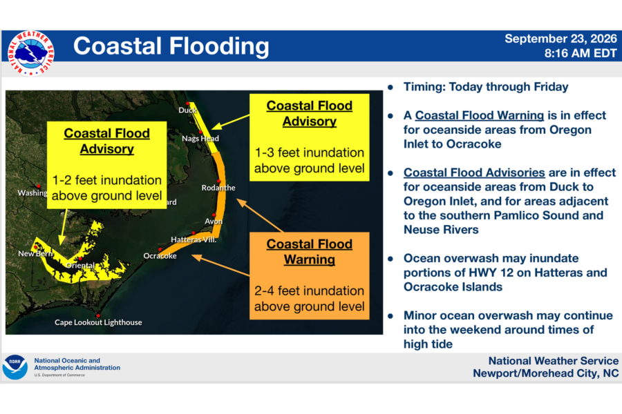
Hatteras Island: Significant Ocean Overwash and Travel Impacts Expected:
Along the Hatteras Island oceanfront, 2 to 4 feet of inundation above ground level flooding is possible, resulting in significant ocean overwash at vulnerable dune locations. Overwash could affect portions of N.C. Highway 12 as well as other low-lying and vulnerable oceanfront areas.
Ocean overwash could begin as early as this evening’s high tide, which occurs around 6 p.m. Conditions are expected to worsen with subsequent high tides, with the most significant impacts anticipated beginning Thursday morning and potentially continuing into the weekend.
Residents and visitors on Hatteras Island should be prepared for hazardous travel conditions and the possibility of temporary closures of N.C. Highway 12.
Everyone is encouraged to minimize unnecessary travel as conditions deteriorate. If you encounter a flooded roadway, turn around, don’t drown. Never drive around barricades or other barriers that have been placed to close a road.
Dangerous Ocean Conditions:
The ocean is unsafe for swimming due to extremely hazardous surf and life-threatening rip currents. Double red flags are posted, indicating that the ocean is closed to swimming until conditions improve.
Large waves and prolonged rough surf are also expected to result in significant beach erosion, particularly in areas with vulnerable or compromised dune structures.
Residents and visitors along the oceanfront—especially those in areas such as the north end of Rodanthe and portions of Buxton—should remain alert and be prepared to take action to protect property from ocean overwash.
Strong Winds Also Expected:
In addition to coastal flooding and overwash, moderate to strong north to northeast winds will continue to affect Dare County. Wind gusts of 40 mph to 50 mph could bring down tree limbs or trees, resulting in isolated power outages and creating hazardous conditions for high-profile vehicles.
Residents and visitors should secure loose outdoor items and be prepared for the possibility of localized power outages.
Road Conditions:
Everyone should be prepared to minimize travel as conditions deteriorate. If travel is necessary, use extreme caution and remain alert for changing road conditions.
For updates regarding road conditions, please visit DriveNC.gov and follow the North Carolina Department of Transportation and NCDOT NC 12 on Facebook.
Stay Informed:
Conditions and forecasts may continue to change as the coastal storm affects the area. Residents, visitors and property owners are strongly encouraged to monitor official weather forecasts and road conditions throughout the event.
For the latest weather information and briefings, visit the National Weather Service at Newport/Morehead City.
For current road conditions and closures from the North Carolina Department of Transportation, visit DriveNC.gov, where you can set alerts to receive notifications for specific areas. For updates specific to N.C. Highway 12 on Hatteras Island, follow NCDOT NC 12 on Facebook.
To receive emergency text alerts from Dare County Emergency Management, text “DareEmergencyAlerts” to 77295.
Dare County Departmental Cancellations:
Dare County Transportation:
Dare County Transportation has announced that due to anticipated storm impacts, transportation services will not operate south of the Marc Basnight Bridge beginning today, Wednesday, September 23, 2026, until road conditions improve. For additional information, please contact the Dare County Transportation office at 252.475.5640.
Additional information regarding any departmental closures and cancellations of county programs and services will be posted at DareNC.gov/Storm as it becomes available.
The post Emergency Management issues coastal storm update; Significant ocean overwash likely on Hatteras Island appeared first on The Outer Banks Life.